This survey addresses Arctic in-situ observations of the ocean, atmosphere, terrestrial sphere and cryosphere, retrieved through established networks/observing systems as well as individual large projects.
The survey builds upon similar efforts to assess climate data record maturity (under the FP7 CORE-CLIMAX project), measurement series maturity (under the H2020 GAIA-CLIM project), data management maturity of the Polar observing systems (under the H2020 EU-PolarNet project)(*), although it addresses somewhat different data and domains.
CONTENT
- Scope of the survey
- Definition of observing system
- How to fill the questionnaire
- Contact info
List of the surveyed observing systems
Map of the surveyed observing systems
(*) Relevant documents produces by the cited projects are the following:
- FP7 CORE-CLIMAX project: CORE-CLIMAX Climate Data Record Assessment. Instruction Manual, CC/EUM/MAN/13/002, EUMETSAT, 2013.
- H2020 GAIA-CLIM project: GAIA-CLIM Measurement Maturity Matrix Guidance, Task 1.1: Report on system of systems approach adopted and rationale, 2015.
- H2020 GAIA-CLIM project: Thorne et al., Making better sense of the mosaic of environmental measurement networks: a system-of-systems approach and quantitative assessment, Geosci. Instrum. Method. Data Syst. Discuss., doi:10.5194/gi-2017-29, in review, 2017.
- H2020 EU-PolarNet project: Deliverable No. 3.1 - Survey of the existing Polar Research data systems and infrastructures, including their architectures, standard/good practice baselines, policies and scopes, 2016
1.Scope of the survey
The survey is designed to serve the objective of INTAROS WP2: Exploitation of existing data. In particular, it aims to evaluate the status of present observing systems with respect to the requirements to build the integrated Arctic Observing System (iAOS). More specifically, the purpose of the survey is to collect the information needed to assess the existing Arctic in-situ observing systems in terms of data delivery chain, accessibility, and spatial-temporal coverage.
A first report on “Present Arctic observing capacities and gaps – Part I” will be based on the survey conducted among the INTAROS partners, and will include, in addition to the assessment of in-situ observing systems, an extensive evaluation of the characteristics of the data collections included (or not) in the observing systems.
A second report “Present Arctic observing capacities and gaps – Part II” will focus on the in-situ observing systems only, and will be based on the integration of the responses collected outside the INTAROS consortium with those answered by the INTAROS partners.
2.Definition of observing system
An observing system consists of a data collection component (infrastructure) and a data management component (e-infrastructure). The data collection component is comprised of multiple sensors either belonging to a common fixed platform (such as tower, mooring, glider, buoy), which can be a single unity or a collection of units forming a network, or installed on a temporary platform (ship, aircraft, UAV, ocean/sea ice/land station). The data collection component stores the datasets internally or transmits them to the data management component. The data management component includes hardware and software for data repository(s), the data processing, data discovery and visualization services. The management can be centralized in a single institution or distributed among several national institutions, which, in many cases, have agreed on common standards for the data and metadata formats, documentation and management. An observing system can be multidisciplinary or focused on a specific discipline, and it serves a clearly identified scientific or operational purpose.
There are many types of observing systems, reflecting a large variety in technical solutions and different maturity and organizational levels of the in situ measurements. For the atmosphere there are several mature observing systems, such as international networks, that follow standardized data managements. In the marine sphere observations are more diversified and fragmented, providing more types of data with various degree of standardization. The marine observing systems are usually identified on the basis of the utilized platforms (moorings, floats, gliders,…), in line with the classification of global observing systems made in the GCOS 2016 Implementation Plan.
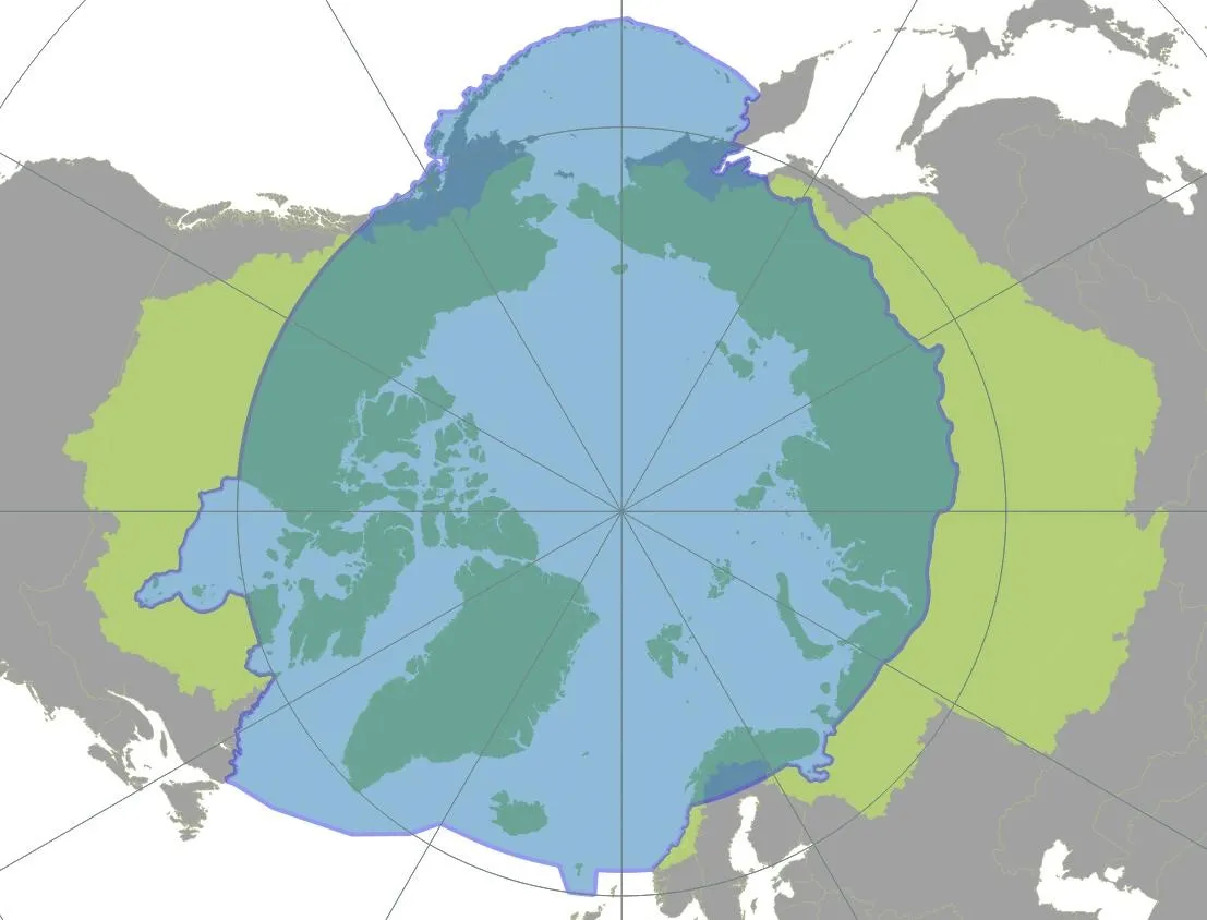
The following list of observing system categories was designed to include the observing systems addressed by the INTAROS partners. It is by no means an exhaustive list, and respondents should not hesitate to introduce additional categories (selecting the option “other”) for their observing system to if they are missing from the given list. Few examples of observing systems are given in parentheses for some of the listed categories. The observing systems should be located inside the boundaries of the Arctic Monitoring and Assessment Program (AMAP), or, in the case of hydrological data, inside the boundaries of the Arctic Ocean Drainage Basins following the AAR (All Arctic Regions) definition proposed by Shiklomanov et al, 2000 (see Figure 3).
|
List of existing category of Arctic observing Networks or Systems:
- ATMOSPHERE: Surface-layer (it includes, e.g., the long-term buoy network, the Global GAW network (Barrow (USA), Sodankylä-Pallas (Finland) and Ny-Alesund (Norway)), the Regional GAW network (Shemya Island, Cold Bay, Poker flat, Ocean Station M (USA), Inuvik, Behchoko, Cambridge Bay, Baker Lake, Churchill, Snare Rapids, Resolute, Eureka, Iqualuit (Canada), Thule, Sondrestrom, Site J, Summit, Station North (Greenland), Reykjavik , Storhofdi, Irafoss (Iceland), Esrange, Tarfala, Luleå (Sweden), Oulanka, Varriö (Finland), Janiskoski, Teriberka, Arkhangelk, Pinega, Tiksi , Yakutsk, Murmansk, Pechora, Baranova, Turukhansk, Dikson Island, Tura, Olenek, Kotelnyj Island, Nagaevo, Markovo (Russia)), the Pan-Eurasian Experiment (PEEX) network; the Tower network for atmospheric trace gas mixing-ratio monitoring (e.g. CO2, CH4, N2O,. ..), or GCOS-affiliated WMO/GAW Global Atmospheric monitoring network (Barrow, CARVE tower Fairbanks (USA), Inuvik, Behchoko, Cambridge Bay, Baker Lake, Alert (Canada), Summit (Greenland), Storhovdi (Iceland), Zeppelin (Norway), Pallas (Finland), Kjolnes (Norway), Igrim, Noyabrsk, ZOTTO, Cape Baranova, Tiksi, Yakutsk, Pleistocene Park, Ambarchik (Russia)); the ICOS-Atmosphere network (Disko, Nuuk, Zackenberg, North (Greenland), Zeppelin (Ny Alesund, Norway), Abisko (Sweden), Pallas, Sodankylä (Finland))
- ATMOSPHERE: Tropospheric profiles (it includes, e.g., the GCOS Upper-Air Network (GUAN), the GCOS Reference Upper-Air Network (GRUAN), the Arctic Radiosonde stations not included in GUAN (from full WWW/GOS radiosonde network, with data archived in the IGRA portal))
- ATMOSPHERE: surface and tropospheric observations collected during field campaigns (only those campaigns (on land, sea ice, or ship-based) including extensive atmospheric observations, in addition to synoptic observations)
- OCEAN: Fixed moorings (it includes, e.g., A-TWAIN, FRAM, ICOS-Ocean)
- OCEAN: Repeated sections (it includes, e.g., AREX)
- OCEAN: Floats (it includes, e.g., NorArgo, ArgoPoland)
- OCEAN: gliders
- OCEAN: ship of opportunity-based network
- OCEAN: sea floor network
- SEA ICE: ice buoys array (International Arctic Buoy Program)
- SEA ICE: observations collected during field campaigns
- LAND: Surface-atmosphere fluxes (it includes, e.g., airborne observations, the Eddy covariance (short-tower) network)
- LAND: Hydrological Arctic observation network
- LAND: INTERACT network
- LAND: Permanent and temporary seismic stations
- TERRESTRIAL CRYOSPHERE: Glacier and Ice Cups (it includes, e.g., the World Glacier Monitoring System)
- TERRESTRIAL CRYOSPHERE: snow (it includes, e.g., Sodankylä observatory (Finland))
- TERRESTRIAL CRYOSPHERE: Greenland Ice Sheet (it includes, e.g., PROMICE, GC-NET, and GPS network)
- Other
3.How to fill the questionnaire
The questionnaire ADDRESSES: existing Arctic in situ observing systems, as defined in Section 6.
The questionnaire DOES NOT ADDRESS: national, sporadic field campaigns, data collections obtained by a single instruments.
Figure 1 illustrates the topics addressed by the questionnaire: each observing system needs to be described in its general characteristics (name and classification, spatial extension, temporal coverage, administrator) and with respect to its sustainability, data management, and data usage.
When the observing system is based on several platforms, it can be surveyed with a single questionnaire if the platforms have common data usage, sustainability, and data management. If this is not the case, please group together the platforms that have common data usage/sustainability/management and fill a separate questionnaire for each group.
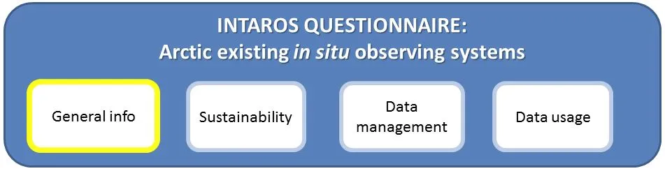
Figure 1. Schematic illustration of the topics addressed in the questionnaire
The respondents are requested to be as objective as possible when answering to the questions, although a certain degree of subjectivity is unavoidable. Undue bias either to painting a too positive or a too negative picture shall be detrimental when we subsequently attempt to compare and synthesize results.
Most of the questions are designed in form of multiple choices, to minimize the effort required by the respondent and the amount of free text to write. Also, the questions are such that an answer should always be found among the available choices (in some cases there is also the option “I don’t know”). If the correct answer is not included in the available choices, the respondent should fill in a free text in the option “Other”. Sometimes several answers may be assessed as true. In such cases the respondent should pick the highest ranking answer that they assess as being met. To facilitate the analysis of the results and to avoid misinterpretation, the respondents are asked to give an answer to all questions. If a respondent meets fundamental difficulties and finds some questions not fitting to the assessed data or system, they are asked to provide explanation on the reasons for not being able to answer to those specific questions.
The questionnaire can be accessed and updated repeatedly until the given deadline. To save it, it is necessary to submit it by pressing the “Submit” button at the end of the questionnaire. After the first submission, an email with the URL address of the response form, needed to access it for successive editing, will be sent to the respondent.
4.Contact info
In case of questions or comments, please contact: intaros-quest @ nersc.no