Sea level is a well-known measure of multiple ongoing processes related to the fast changing climate in the Arctic. The enhanced deglaciation of land, decline of sea ice cover and ocean freshening, warmer ocean water is all affecting sea level. Hence observing sea level is paramount for monitoring Arctic climate change.
Challenges: Sea level are mainly observed by either tide gauges that measures the sea level directly from the coast or by satellite radar altimetry that measures the distance between the satellite and the ocean. Both methods are unfortunately severely challenged in the Arctic. Due to the harsh and remote environment tide gauges are expensive to install and maintain. Consequently, only few good tide gauges og long time series exists (10-15). These are however along the rim of the Arctic Ocean and furthermore associated with river outlets hampering their ability to measure sea level. Tide gauges also just measure the sea level relative to the coast and will be influence by vertical deformation of the ground. In the Arctic, this is in particular relevant, since ice mass loss lifts the subsurface. Other processes like oil depletion, nearby constructions etc. result in small vertical deformation that affects the sea level observations. This deformation can be corrected by near-by GNSS-sites, but only few combinations of tide-gauges/GNSS exist in the Arctic. With satellite altimetry sea level data are routinely retrieved from open ocean. However, in the Arctic the sea ice limits the araes where altimter data are useful. Since 2010 CryoSat-2 has provided altimetric observations of sea ice araes up to 88N, but sea level data is only retrieved from wide leads in the sea ice cover. Validation of long term sea level changes can be done by decomposing the observed sea level into it driving components. These are changes in mass from adding water and steric changes (from changing temperature (T) and salinity (S) change). Mass changes are observed by gravmetric satellites (GRACE and GRACE-FO), but the poor resolution of GRACE (300-500 km) hampers its ability to monitor ocean mass changes in the Arctic.
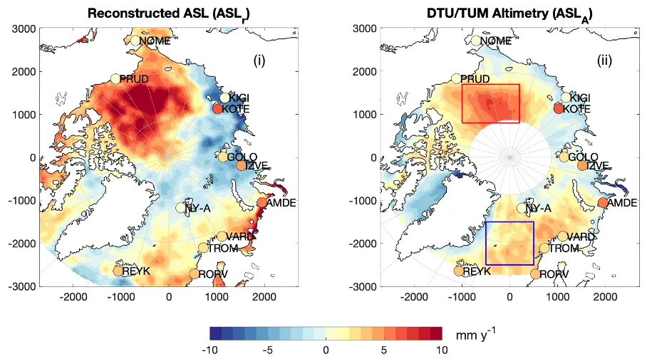
Left plot: Absolute sea level trend of the reconstructed product (steric+mass) (ASLr). Right plot: Map provided by DTU/TUM Altimetry (ASLA) from 1995 to 2015 [mm y-1 ]. In both maps the sea level trend of the 12 vertical deformation-corrected tide gauges (ASLTG) is shown by circles. Copyright: Carsten A. Ludwigsen, DTU.
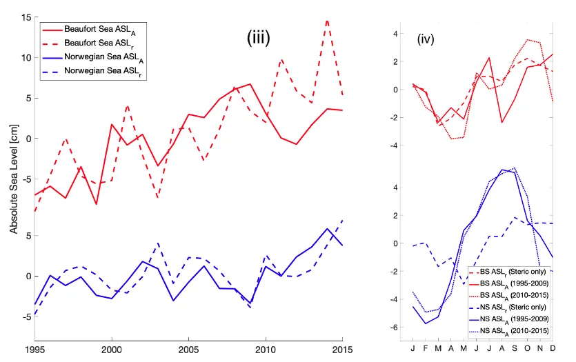
Left plot: Timeseries of ASLA and ASLr for two selected regions, Norwegian Sea (NS) and Beaufort Sea (BS) (marked in the DTU/TUM Altimetry map). Right plot: the mean seasonal cycle for two periods of ASLA (solid line: 1995-2009, dotted line: 2010-2015) and ASLr (dashed line) for the same two regions as in the left plot. Copyright: Carsten A. Ludwigsen, DTU.
Results from INTAROS. Attempts to separate land signals from ocean signals, results in large discrepancies among different GRACE estimates which was shown in Ludwigsen and Andersen (2021) in the initial phase of the INTAROS project. In the same publication, it was highlighted that in-situ T/S-profiles, necessary to calculate the steric sea level change, are extremely sparse in large regions of the Arctic Ocean. Nevertheless, we successfully performed an interpolation of all available T/S-profiles (from the UDASH-database, Behrendt et al, 2017) which resulted in a decent steric estimate that was recognizable in altimetric observations that outperformed modelled steric estimates.
Specialized methods to classify and retrack sea level observations from radar altimetry since 1991 to 2018 has been utilized and published in Rose et al (2019) (DTU/TUM altimetry product). The altimetric sea level record achieved very good correlation with observations from tide gauges in the Arctic. The main regions of disagreement were found in the East Siberian Arctic.
To further improve the usage of tide-gauges for sea level studies, an Arctic global vertical deformation-model was created in Ludwigsen et al, 2020 in order to model and correct for vertical deformation of the ground where the tide gauges rests, in the entire Arctic, and thereby usable as GNSS-alternative in regions with no GNSS information.
Instead of using questionable GRACE to estimate long-term mass changes, Ludwigsen et al (2021, in discuss.) attempted to reconstruct the mass changes from geoid changes caused by land loss and adding a atmospheric load contribution (Inverse Barometer effect). Together with the steric estimate in Ludwigsen and Andersen (2020), the obtained a good agreement with the long-term satellite altimetric observations of Rose et al (2019), hereby validating both datasets. Disagreements are however still observed in particular in the Beaufort Gyre and East Siberian Sea.
References:
Ludwigsen, Carsten Ankjær, et al. “Vertical Land Motion From Present‐Day Deglaciation in the Wider Arctic.” Geophysical Research Letters, vol. 47, no. 19, Blackwell Publishing Ltd, 2020, p. e2020GL088144, doi:10.1029/2020GL088144.
Ludwigsen, C. A., & Andersen, O. B. (2021). Contributions to Arctic sea level from 2003 to 2015. Advances in Space Research, 68(2), 703–710. https://doi.org/10.1016/j.asr.2019.12.027
Rose, S., Andersen, O. B., Passaro, M., Ludwigsen, C. A., & Schwatke, C. (2019). Arctic Ocean Sea Level Record from the Complete Radar Altimetry Era: 1991-2018. Remote Sensing, 11(14), 1672. https://doi.org/10.3390/rs11141672
Behrendt, A., Sumata, H., Rabe, B., & Schauer, U. (2018). UDASH - Unified Database for Arctic and Subarctic Hyd