Challenges: Measurements of some key snow variables such as snow depth, snow water equivalent (SWE), and snow grain size are still done mostly by manual methods and, thus, expensive and time consuming. This strongly limits the spatial extension of the measurement network. Snow grain size and albedo are very rarely measured, but time series of these variable through the snow season are important to obtain. Depending on orography and surface types, the spatial variability of snow depth, SWE and albedo may be large in satellite and model footprints, making measurements from single ground-based stations poorly representative for validation of model and satellite snow products. Ideally, in supersites such as Sodankylä (Finland) and Hornsund (Svalbard), which are used as calibration/validation reference for satellite snow products, snow monitoring should be achieved through a dense local network of snow stations with associated assessment of their spatial representativeness. This is partially done, but representativeness assessment is still lacking. At the location of greenhouse gas observation towers, snow measurements are rarely done, although they would be very important for the interpretation of the measured greenhouse gas fluxes. Uncertainty characterization and management of in-situ snow observations are generally poor, preventing a proper exploitation of the data for validation/development of models and satellite products.
Results obtained in INTAROS. The Sodankylä in-situ observation system was enhanced with a SodScat scatterometer and the SVC-FMI spectro-albedometer that enable continuous measurements of key snow parameters (SWE, albedo, optical-equivalent snow grain size, microwave-equivalent snow grain size). Furthermore, prrogress has been made in integration of the existing multidisciplinary observational portfolio of soil, ecosystem, cryosphere, and atmosphere (troposphere, clouds stratosphere, ionosphere) observations. The contribution of INTAROS to this enhancement of the observational capacities consisted in the testing of these two new devices (purchased with other funding) and the development of the data acquisition and processing chain (measurement protocol, data quality control, software for raw data processing, data format and storage). This complete system will provide a unique dataset of ready-to-use spectra of irradiance and albedo that have already been requested by ECMWF and remote sensing scientists. The SodScat radar is installed on the Integrated Carbon Observing System (ICOS) tower at Sodankylä, which hosts a variety of sensors for monitoring CO2 and CH4 flux and concertation, radiation and thermal balance, as well as snow, soil and atmospheric properties. This enables cross-cutting studies with observing changes in CO2 emission by means of proxy parameters derived from microwave remote sensing (e.g. snow cover and soil properties and their relation to the carbon balance).
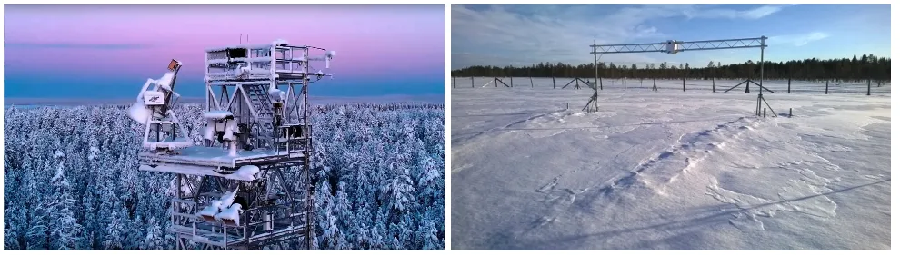
Legend: Instruments installed at the Sodankylä supersite in INTAROS. Left figure: The SodScat is lowermost instrument installed on the top platform of the ICOS tower. Right figure: The SVC-FMI spectro-albedometer is installed on the rail looking downwards. Copyright: Roberta Pirazzini, FMI.