Introduction to the survey of Existing Observing systems
1.Scope of the survey
The survey is designed to serve the objective of WP2: Exploitation of existing data. In particular, it aims to evaluate the status of present observing systems with respect to the requirements to build the integrated Arctic Observing System (iAOS). More specifically, the purpose of the survey is:
- To collect the information needed to assess the existing Arctic in-situ observing systems in terms of data delivery chain, accessibility, and spatial-temporal coverage, (questionnaire A),
- To assess the technological readiness, coverage, resolution, uncertainty, metadata and documentation of selected in-situ data collections (including airborne data) that may or may not belong to established networks and catalogue them for use in the integrated system in WP5 (questionnaire B), and
- To assess the usage, management, coverage, resolution, uncertainty, metadata and documentation of selected satellite-based products and catalogue them for use in the integrated system in WP5 (questionnaire C).
The survey responses shall form the basis for the WP2 reports and deliverables (see Figure 1). It is therefore important that the survey is conducted carefully.
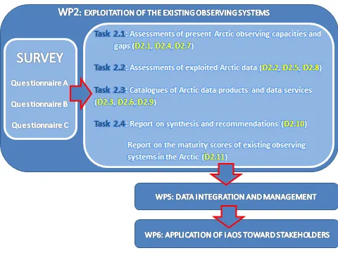
Figure 1. Flowchart illustrating the role of the questionnaires in INTAROS
A synthesis of the maturity matrices will be provided in in Task 2.4, and summarized in the deliverable D2.11 (Report on the maturity scores of existing observing systems in the Arctic). Finally, part of the collected information will be utilized to produce data catalogues (D2.3, D2.6, D2.9) which are needed by WP5 (Data integration and management) to build the iAOS. The iAOS will enable easy access to data from multiple repositories for the application studies carried out in WP6 (Application of iAOS toward stakeholders).The flowchart in Figure 1 illustrates the role of the questionnaires in INTAROS.
2.observing systems and data addressed in the questionnaires
Questionnaire A
The questionnaire ADDRESSES: existing Arctic in situ observing systems, as defined in Section 6.
The questionnaire DOES NOT ADDRESS: data collections obtained by a single instrument (they are the target of questionnaire B).
Questionnaire B
The questionnaire ADDRESSES: existing Arctic in situ data collections, as defined in Section 6.
The questionnaire DOES NOT ADDRESS: model-generated data and re-analysis products.
We cannot fill the questionnaires for ALL the existing Arctic data that belong to the addressed types. We therefore recommend that respondents prioritize those data that they consider most relevant for the demonstrative applications in WP6, and in general for the user communities.
Questionnaire C
The questionnaire ADDRESSES: Arctic satellite products that are relevant for INTAROS.
The questionnaire DOES NOT ADDRESS: Level 0 and level 1 data as well as level 4 data (model output)
3.Surveyed topics
Figure 2 summarises the topics addressed by the three questionnaires.
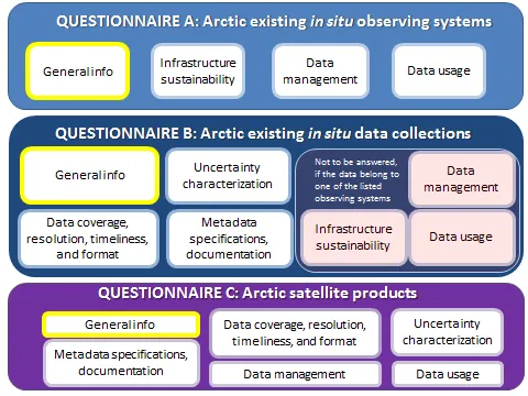
Figure 2. Schematic illustration of the topics addressed in the three questionnaires
For each analyzed IN SITU DATA COLLECTION, we plan to conduct a maturity assessment, which includes both aspects specific of the observing systems (such as sustainability, data management, and data usage) and aspects that are peculiar to the considered data collection (such as coverage, quality, resolution, metadata characteristics and documentation). As an in situ observing system may include several different data collections, we have developed a separate questionnaire (questionnaire A) for the observing systems, that examines the specific aspects of the observing systems but not the characteristics of the data collections included in the systems. Questionnaire B will examine the characteristics of the data collections, and here the respondents are asked to specify if the addressed in situ data collection does belong to one of the Observing Systems listed in Sect. 6:
- If YES, the questions related to infrastructure sustainability, data management, and data usage, already made in questionnaire A, will be skipped, and the respondent to questionnaire B should consider to fill also questionnaire A for that identified Observing System (to be filled only once for all the data collections belonging to the observing system!).
- If NO, the respondent will be asked to answer also the questions related to sustainability of the observing system, data management, and data usage.
The available SATELLITE PRODUCTS are evaluated through questionnaire C. The survey covers data characteristics such as spatial and temporal coverage, resolution, quality, as well as data management, metadata specifications, documentation, and data usage.
4.Who ARE asked to fill the questionnaires
The questionnaires should be filled (at least) by all INTAROS partners working in Tasks 2.1, 2.2, and 2.3. Partners working on Task 2.1 should use the questionnaires to complete their assessment. If the work includes research activities that aim to determine specific data characteristics (such as data uncertainty, or spatial representativeness), the questionnaire concerning those data should account for the results achieved (thus, it has to be filled at the end of the planned work). Partners working on Task 2.2 to develop higher-level data products, and partners working on Task 2.3 to standardize data/metadata and to integrate sparse data into established repositories should fill the questionnaires addressing the upgraded data versions (thus, they should fill the questionnaire at the end of their work). In this way, the assessment reports and data catalogues that will be produced utilizing the answers of the questionnaires will illustrate the state-of-art of the existing Arctic observing systems after the exploitation activity carried out in WP2.
Questionnaire A should be filled by scientists or technicians experienced in the assessed in situ observing system (see definition in Section 6). If the respondent does not have the information needed to answer to some questions, he/she should contact the managers of the observing systems. In case the observing system is operated by a non-INTAROS partner, the system manager will be asked to fill the questionnaire. The names of the observing systems surveyed through questionnaire A are collected in a list, accessible from the main web page of the survey. It is desirable to get more than one filled questionnaire for each observing system (by different experts), to increase the robustness of the maturity assessment.
Questionnaires B and C should be filled by those scientists or technicians expert in or responsible for the assessed in situ data collection (questionnaire B) and satellite product (Questionnaire C). In situ data collections may or may not belong to existing observing networks/systems (see definition in section 6). In case they do belong to such networks / systems, the respondent to questionnaire B should consider responding also to questionnaire A for the specific observing system (if he/she has easy access to the required information, or he/she knows whom to contact to get that information). In case the in situ data collections do not belong to an existing observing network/system, the respondent of questionnaire B is asked to answer to some extra sections of questionnaire B related to infrastructure and data management.
5.How to fill the questionnaires
The respondents are requested to be as objective as possible when answering to the questions, although a certain degree of subjectivity is unavoidable. Undue bias either to painting a too positive or a too negative picture shall be detrimental when we subsequently attempt to compare and synthesize results.
Most of the questions are designed in form of multiple choices, to minimize the effort required by the respondent and the amount of free text to write. Also, the questions are such that an answer should always be found among the available choices (in some cases there is also the option “I don’t know”). If the correct answer is not included in the available choices, the respondent should fill in a free text in the option “Other”. Sometimes several answers may be assessed as true. In such cases the respondent should pick the highest ranking answer that they assess as being met. To facilitate the analysis of the results and to avoid misinterpretation, the respondents are asked to give an answer to all questions. If a respondent meets fundamental difficulties and finds some questions not fitting to the assessed data or system, they are asked to provide explanation on the reasons for not being able to answer to those specific questions.
The first Section of questionnaire A collects the information needed to locate the in situ observing system in a map, with some basic labelling (domain, administrator, spatial-temporal coverage). Questionnaire A should be submitted as soon as Section 1 is completed, eventually by leaving all the remaining questions unanswered, because the contents of Section 1 will be used to regularly update the map and the name list of the existing observing systems. The questionnaire is submitted after pressing the button “Submit” at the end of the questionnaire. The questionnaire can be accessed and updated repeatedly until the given deadline. After each submission, a page will appear with the following text:
Your response has been recorded.
See previous responses
Edit your response
Click on "Edit your response", save the URL of the appeared editing page, and reuse that link every time you need to access, update, and resubmit the form.
6.Definitions
Observing System
An observing system consists of a data collection component (infrastructure) and a data management component (e-infrastructure). The data collection component is comprised of multiple sensors either belonging to a common fixed platform (such as tower, mooring, glider, buoy), which can be a single unity or a collection of units forming a network, or installed on a temporary platform (ship, aircraft, UAV, ocean/sea ice/land station). The data collection component stores the datasets internally or transmits them to the data management component. The data management component includes hardware and software for data repository(s), the data processing, data discovery and visualization services. The management can be centralized in a single institution or distributed among several national institutions, which, in many cases, have agreed on common standards for the data and metadata formats, documentation and management. An observing system can be multidisciplinary or focused on a specific discipline, and it serves a clearly identified scientific or operational purpose.
There are many types of observing systems, reflecting a large variety in technical solutions and different maturity and organizational levels of the in situ measurements. For the atmosphere there are several mature observing systems, such as international networks, that follow standardized data managements. In the marine sphere observations are more diversified and fragmented, providing more types of data with various degree of standardization. The marine observing systems are usually identified on the basis of the utilized platforms (moorings, floats, gliders,…), in line with the classification of global observing systems made in the GCOS 2016 Implementation Plan.
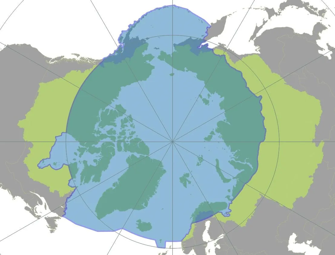
The following list of observing system categories was designed to include the observing systems addressed by the INTAROS partners. It is by no means an exhaustive list, and respondents to Questionnaire A should not hesitate to introduce additional categories (selecting the option “other”) for their observing system to if they are missing from the given list. Few examples of observing systems are given in parentheses for some of the listed categories. The observing systems should be located inside the boundaries of the Arctic Monitoring and Assessment Program (AMAP), or, in the case of hydrological data, inside the boundaries of the Arctic Ocean Drainage Basins following the AAR (All Arctic Regions) definition proposed by Shiklomanov et al, 2000 (see Figure 3).
|
List of the existing Arctic observing Networks or Systems:
- ATMOSPHERE: Surface-layer (it includes, e.g., the long-term buoy network, the Global GAW network (Barrow (USA), Sodankylä-Pallas (Finland) and Ny-Alesund (Norway)), the Regional GAW network (Shemya Island, Cold Bay, Poker flat, Ocean Station M (USA), Inuvik, Behchoko, Cambridge Bay, Baker Lake, Churchill, Snare Rapids, Resolute, Eureka, Iqualuit (Canada), Thule, Sondrestrom, Site J, Summit, Station North (Greenland), Reykjavik , Storhofdi, Irafoss (Iceland), Esrange, Tarfala, Luleå (Sweden), Oulanka, Varriö (Finland), Janiskoski, Teriberka, Arkhangelk, Pinega, Tiksi , Yakutsk, Murmansk, Pechora, Baranova, Turukhansk, Dikson Island, Tura, Olenek, Kotelnyj Island, Nagaevo, Markovo (Russia)), the Pan-Eurasian Experiment (PEEX) network; the Tower network for atmospheric trace gas mixing-ratio monitoring (e.g. CO2, CH4, N2O,. ..), or GCOS-affiliated WMO/GAW Global Atmospheric monitoring network (Barrow, CARVE tower Fairbanks (USA), Inuvik, Behchoko, Cambridge Bay, Baker Lake, Alert (Canada), Summit (Greenland), Storhovdi (Iceland), Zeppelin (Norway), Pallas (Finland), Kjolnes (Norway), Igrim, Noyabrsk, ZOTTO, Cape Baranova, Tiksi, Yakutsk, Pleistocene Park, Ambarchik (Russia)); the ICOS-Atmosphere network (Disko, Nuuk, Zackenberg, North (Greenland), Zeppelin (Ny Alesund, Norway), Abisko (Sweden), Pallas, Sodankylä (Finland))
- ATMOSPHERE: Tropospheric profiles (it includes, e.g., the GCOS Upper-Air Network (GUAN), the GCOS Reference Upper-Air Network (GRUAN), the Arctic Radiosonde stations not included in GUAN (from full WWW/GOS radiosonde network, with data archived in the IGRA portal))
- ATMOSPHERE: surface and tropospheric observations collected during field campaigns (only those campaigns (on land, sea ice, or ship-based) including extensive atmospheric observations, in addition to synoptic observations)
- OCEAN: Fixed moorings (it includes, e.g., A-TWAIN, FRAM, ICOS-Ocean)
- OCEAN: Repeated sections (it includes, e.g., AREX)
- OCEAN: Floats (it includes, e.g., NorArgo, ArgoPoland)
- OCEAN: gliders
- OCEAN: ship of opportunity-based network
- OCEAN: sea floor network
- OCEAN: tide gauge network
- SEA ICE: ice buoys array (International Arctic Buoy Program)
- SEA ICE: observations collected during field campaigns
- LAND: Surface-atmosphere fluxes (it includes, e.g., airborne observations, the Eddy covariance (short-tower) network)
- LAND: Hydrological Arctic observation network
- LAND: INTERACT network
- LAND: Permanent and temporary seismic stations
- TERRESTRIAL CRYOSPHERE: Glacier and Ice Cups (it includes, e.g., the World Glacier Monitoring System)
- TERRESTRIAL CRYOSPHERE: snow (it includes, e.g., Sodankylä observatory (Finland))
- TERRESTRIAL CRYOSPHERE: Greenland Ice Sheet (it includes, e.g., PROMICE, GC-NET, and GPS network)
- COMMUNITY BASED PROGRAM
- Other
In situ data collection
It is here defined as a collection of data, or measurement series, that have common characteristics in terms of quality, resolution, and coverage. In most cases, the instrumentation used to collect the data determines the characteristics of the collection. In the present survey, the instruments applied to collect the data range from manual tools to fully automatized sensors. Thus, a data collection generally includes all the variables measured with a single instrument. In situ data collections also include derived data products which result from processing of individual measurements or composition of multiple measurements. In situ data collections can be surface-, subsurface-, and air-borne.
We address different kind of data collections: 1) data from established in situ networks, having regional (or Pan-Arctic) spatial coverage and variable temporal coverage, 2) data from single stations, having local areal coverage and variable temporal coverage, 3) data from field campaigns (land-, ship-, aircraft-, UAV-based measurements), with limited temporal coverage and from point to regional spatial coverage.
Satellite products
Observational data acquired by satellite instruments are processed up to different levels before distribution to the users. The result of processing is a product (WMO, http://www.wmo.int/pages/prog/sat/dataandproducts_en.php).
7.Contact persons
In case of questions or comments, INTAROS partners contributing to WP2 should contact the leader of the task to which their work belongs. INTAROS collaborators who are not partners can contact any of the Task leaders:
Michael Tjernström (michaelt@misu.su.se), leader of Task 2.1
Andreas Ahlstrøm (apa@geus.dk), leader of Task 2.2
Ingo Schewe (ingo.schewe@awi.de), leader of Task 2.3